6 Reasons to Redeem Your Futureview East Ticket
Image File
Original HTML

6 Reasons to Redeem Your Futureview East Ticket

If your organization has Futureview tickets available, now is the time to put them to use.

Futureview East 2026 will take place September 22–25, 2026, in Louisville, Kentucky, bringing Eagleview customers together for training, product education, networking, and real-world learning.

For many customers, Futureview East represents more than a conference. It is an opportunity to strengthen your team’s knowledge, explore new ways to use Eagleview solutions, and bring practical ideas back to your organization.

To check whether your organization has existing passes or to get your discount codes, contact your District Manager or reach out to events@marketing.eagleview.com.

Here are six reasons to redeem your Futureview East ticket.

Build Stronger Eagleview Skills

Futureview East is designed to help customers get more from Eagleview imagery, software, and geospatial intelligence.

Through expert-led sessions and product-focused learning, attendees can deepen their understanding of Eagleview capabilities and discover ways to apply them more effectively in day-to-day workflows.

Whether your team is focused on property assessment, GIS, public safety, public works, or cross-department collaboration, Futureview East gives attendees direct access to training and insights that can support better adoption and stronger results.

Learn From Real Customer Examples

One of the most valuable parts of Futureview is the opportunity to hear how other organizations are using Eagleview.

Customer stories can help teams understand what is possible, what has worked elsewhere, and how other agencies are addressing similar challenges.

At previous Futureview events, sessions included customer insights, best practices, and hands-on learning. The 2023 event featured more than 50 sessions and welcomed public-sector professionals from across the United States and beyond.

Futureview East continues that tradition by creating space for practical, peer-driven learning.

Explore New Ideas for Modernizing Workflows

Government teams are constantly looking for ways to improve efficiency, increase accuracy, and make better use of data.

Futureview East gives attendees a chance to step away from daily demands and think strategically about how aerial imagery and geospatial intelligence can support modernization.

Attendees may discover new ways to:

- Improve assessment workflows

- Support remote review and field efficiency

- Strengthen GIS data and decision-making

- Enhance public safety planning and response

- Improve infrastructure visibility

- Connect imagery across departments

- Demonstrate return on investment

The goal is not just to learn about technology. It is to identify practical ways to use that technology to support better outcomes.

Connect with Eagleview Experts and Peers

Futureview East brings Eagleview customers, experts, partners, and industry professionals together in one place.

That creates opportunities for conversations that are difficult to replicate through email or virtual meetings. Attendees can ask questions, share challenges, compare approaches, and build relationships with others who understand similar workflows.

For organizations that use Eagleview across multiple departments, the event can also help teams think more broadly about adoption, collaboration, and long-term value.

Make the Most of Tickets Your Organization Already Has

Many Eagleview customers already have Futureview tickets available through existing agreements. Redeeming those tickets for Futureview East is a practical way to make sure your organization gets the full value of that benefit.

Sending the right team members can help your organization return with stronger product knowledge, new workflow ideas, and a clearer understanding of how to apply Eagleview solutions more effectively.

If your organization has available tickets, Futureview East is the right opportunity to use them.

Hear From Keynote Speaker Gregory Robinson

Futureview East attendees will also have the opportunity to hear from keynote speaker Gregory Robinson, former director of NASA’s James Webb Space Telescope Program.

Robinson’s story is especially relevant for Eagleview customers because it sits at the intersection of leadership, technology, imagery, data, and decision-making. The James Webb Space Telescope is known around the world for its stunning images of deep space, but those images are more than beautiful views of the universe. They help scientists observe, measure, analyze, and better understand complex environments that cannot be fully understood from the ground.

That idea connects directly to the work Eagleview customers do every day.

While Eagleview customers are focused on communities here on Earth, they also rely on imagery to see more clearly, derive meaningful data, and make better decisions. High-resolution aerial imagery can help assessment teams validate property data, GIS teams strengthen maps and analysis, public safety teams improve situational awareness, and public works teams better understand infrastructure and changing conditions.

Robinson’s keynote will offer attendees a powerful perspective on leading complex, technology-enabled missions — and on how better imagery, better data, and better collaboration can help teams solve difficult problems with confidence.

And maybe one unofficial seventh reason: make it a long weekend in Louisville

Futureview East wraps up just as one of Louisville’s biggest entertainment weekends is getting underway.

Bourbon & Beyond, the music, food, and bourbon festival, is scheduled for September 24–27, 2026, in Louisville. For attendees who want to extend their stay after Futureview East, the festival could be another reason to make the most of the trip and enjoy a longer weekend in the city.

Of course, Futureview East is reason enough to come to Louisville. But for attendees looking to experience even more of what the city has to offer, the timing creates a fun opportunity to combine professional development with a memorable weekend.

Join us in Louisville

Futureview East 2026 will take place September 22–25 at the Louisville Marriott Downtown. The event is designed to help Eagleview customers learn, connect, and innovate through training, product education, customer stories, peer networking, and a keynote from Gregory Robinson.

- Customers with existing Futureview tickets can redeem their passes and register for Louisville or purchase addition passes here.

- If your organization would rather attend Futureview West, registration opens September 1, 2026.

- To check whether your organization has existing passes or to get your discount codes, contact your District Manager or reach out to events@marketing.Eagleview.com.

Hope to see you in Louisville!
Class (B2B/B2C)
B2B
Ingest Status
Rewritten
Dedupe hash
b0d2353d75d140eeebd53a0f24159989
Press Eligible
Yes
Press Eligible Reason
Promotes a professional customer conference focused on geospatial technology, training, and industry networking.
Source Name
Eagleview
Original Summary

<p>Have a Futureview ticket? Here are five reasons to redeem it for Futureview East 2026 in Louisville.</p>
<p>The post <a href="https://www.eagleview.com/blog/6-reasons-to-redeem-your-futureview-east… Reasons to Redeem Your Futureview East Ticket</a> appeared first on <a href="https://www.eagleview.com">Eagleview</a>.</p&gt;

Image URL
https://www.eagleview.com/wp-content/uploads/2026/06/Futureview-Louisville-Feature-Image.png
Source Node
Content Hash (SHA-256, erste 32 hex)
c1f390caf0046ac0bb9074f860d9ca82
Eagleview Warns Emergency Managers: A Below Average Hurricane Season Is Not a Safe Season
Image File
Original HTML

Eagleview Warns Emergency Managers: A Below Average Hurricane Season Is Not a Safe Season

Company releases 2026 Atlantic hurricane season preparedness briefing, urging full readiness despite below-average forecasts from NOAA, Colorado State University, and AccuWeather

ROCHESTER, N.Y. — Eagleview, an industry leader in geospatial intelligence (GeoAI) delivering AI-powered property intelligence solutions, today released a 2026 Atlantic hurricane season preparedness briefing with a direct message for emergency managers: a below average season does not equal low risk. Despite projections from NOAA, Colorado State University (CSU), and AccuWeather pointing to a below-average season, the company warns that seasonal storm counts are a poor proxy for understanding community-level risk and that every landfalling hurricane demands full preparedness regardless of the forecast.

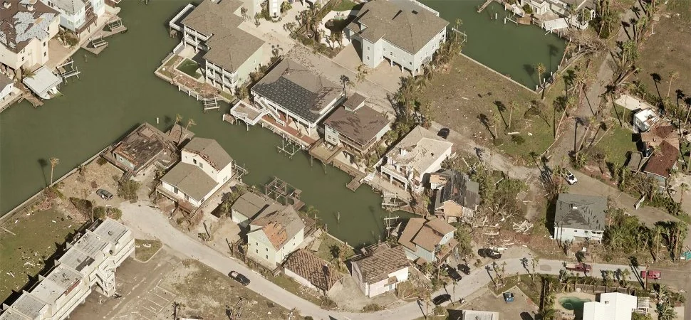
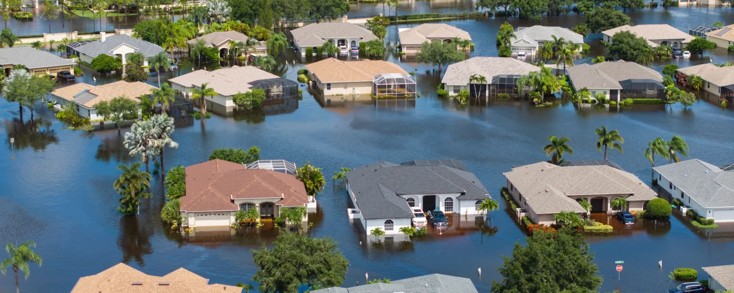
The case is grounded in history. The 1992 Atlantic hurricane season produced just six named storms, well below the 30-year average of 14.4, yet generated Hurricane Andrew, a Category 5 storm that destroyed more than 63,000 homes in South Florida and caused $27.3 billion in damage (equivalent to approximately $67 billion in 2026 dollars). Andrew remains among the most destructive natural disasters in American history, and its season ranks among the quietest on record.

“It only takes one storm to create a catastrophe. The agencies that respond most effectively after a hurricane are those that prepared before the first advisory was ever issued,” shared Robert Locke, President of Eagleview’s Government business unit.

Fast Facts: 2026 Hurricane Season at a Glance

The following data points are drawn from publicly available forecasts and historical records.

Why Below-Average Forecasts Still Demand Full Readiness

Three compounding factors ensure that any landfalling hurricane in 2026 will be more consequential than a comparable storm a generation ago:

- Rapid intensification. Research published in Nature Communications and the Bulletin of the American Meteorological Society documents a significant increase in rapid intensification events, defined as a gain of 35+ mph in sustained winds within 24 hours, since the 1980s. A tropical storm at 8 AM can be a major hurricane the following morning, compressing warning timelines for coastal communities.

- Rising sea levels. Mean sea level along U.S. Gulf and Atlantic coasts has risen measurably over recent decades, per NOAA tide gauge data. Storm surge now rides atop a higher baseline, meaning a Category 2 hurricane in 2026 can produce surge impacts equivalent to a Category 3 in 1990.

- Coastal population growth. U.S. coastal county populations have grown substantially since 1970 (NOAA). More people, more structures, and more critical infrastructure are now concentrated in hurricane-vulnerable zones than at any point in history.

Pre-Event Preparation as an Operational Necessity

Eagleview maintains the most comprehensive library of high-resolution aerial imagery in the United States and Canada, covering 96% of the U.S. population with multi-angle oblique and orthogonal captures. This imagery provides the pre-event baseline emergency managers need to conduct rapid, defensible change detection after a storm.

The company’s dedicated Weather Team monitors tropical development throughout hurricane season and coordinates with Eagleview’s Disaster Response Team to pre-position aerial capture assets ahead of anticipated impact zones enabling post-event imagery delivery to clients typically within days of landfall.

Post-event AI-powered damage classification enables side-by-side pre- and post-storm imagery comparison at scale, supporting Preliminary Damage Assessment (PDA) workflows, FEMA Public Assistance documentation, and resource allocation decisions at a speed ground teams alone cannot achieve.

Availability

The full white paper, “Below Average Does Not Equal Low Risk: A 2026 Atlantic Hurricane Season Preparedness Briefing for Emergency Management Professionals,” is available for download here. Emergency managers interested in pre-disaster agreements for rapid post-event imagery and analytics can contact Eagleview’s Disaster Response Program directly.

About Eagleview

Eagleview is an industry leader in geospatial intelligence (GeoAI), delivering AI-powered property intelligence solutions that enable customers across a broad range of industries to accurately explore properties and structures, identify and implement solutions today, and find tomorrow’s opportunities. For more than 25 years, Eagleview has built proprietary property imaging technology earning more than 300+ patents and generating over 3.5 billion high-resolution images resulting in a library that encompasses 96% of the U.S. population. With Eagleview’s trusted insights, customers can make business decisions that matter.

Media Contact

Kristina Libby

Class (B2B/B2C)
B2B
Ingest Status
Rewritten
Dedupe hash
d2b11d0450b2f61c739891ea979307db
Press Eligible
Yes
Press Eligible Reason
Manuelle Prüfung nötig. Risiko: MEDIUM. Flags: ['finance', 'numbers']. Stichprobe: False
Source Name
Eagleview
Original Summary

<p>Company releases 2026 Atlantic hurricane season preparedness briefing, urging full readiness despite below-average forecasts from NOAA, Colorado State University, and AccuWeather ROCHESTER, N.Y. — Eagleview, [&#8230;]</p>
<p>The post <a href="https://www.eagleview.com/news-announcements/eagleview-warns-emergency-… Warns Emergency Managers: A Below Average Hurricane Season Is Not a Safe Season</a> appeared first on <a href="https://www.eagleview.com">Eagleview</a>.</p&gt;

Image URL
https://www.eagleview.com/wp-content/uploads/2026/07/DRP-Whitepaper-Blog-Graphic.png
Source Node
Content Hash (SHA-256, erste 32 hex)
b5a0aa932eb10370b65448daf5947bd9
Operational Efficiency in Insurance Is No Longer About Doing More with Less. It’s About Knowing More Before You Go.
Image File
Original HTML

Operational Efficiency in Insurance Is No Longer About Doing More with Less. It’s About Knowing More Before You Go.

By Patrick Gill, Senior Vice President & General Manager, Insurance & Commercial Solutions

For years, conversations about operational efficiency in insurance have focused on a single objective: reducing expense. Automate a process. Eliminate a manual task. Shorten cycle times. Remove unnecessary steps.

Those are all worthwhile goals. But they miss the bigger opportunity. The next era of operational efficiency is not simply about working faster. It is about making better decisions because you have better information before work ever begins. That distinction matters.

Insurance has historically operated in a world where too many decisions were made only after someone arrived at a property. Adjusters drove to a home to understand its condition. Contractors climbed onto roofs to measure them. Claims managers waited for inspections before deciding how to allocate resources. Catastrophe teams often reacted only after losses started flooding into the organization.

The result was not just slower claims. It was uncertainty. Multiple site visits. Duplicate work. Inconsistent decisions. Expensive resources deployed where they were not needed while higher-priority claims waited.

Artificial intelligence is changing that equation. Not because AI replaces adjusters or claims professionals. It does not. AI creates operational efficiency because it allows insurers to know dramatically more before anyone leaves the office. That is a fundamentally different way to think about claims operations.

Operational Efficiency Begins with Better Information

At Eagleview, we have spent more than two decades helping insurers understand properties through aerial imagery and property intelligence.

At first, that meant solving a very practical problem.

Roof measurements were often disputed. Adjusters, contractors and homeowners could all arrive at different answers for something as straightforward as the size of a roof. Those disagreements introduced friction into nearly every roofing claim.

Providing objective, independent measurements removed that uncertainty. Everyone could work from the same set of facts. That alone created enormous operational efficiencies.

But measurements were really just the beginning.

Today, insurers have access to an entirely different level of property intelligence: roof condition, roof age, structural attributes, historical imagery, property changes over time, weather intelligence and AI-powered change detection.

Each new layer of information answers another question before someone has to ask it in the field.

Our internal mantra has become simple:

How much better can you operate if you know more before you go?

As it turns out, the answer is: substantially better.

AI Changes the Economics of Claims Operations

One of the biggest misconceptions about artificial intelligence is that it is primarily about automation.

The real opportunity is intelligence.

Claims organizations already employ experienced professionals who know how to make difficult decisions. Their challenge is not capability. It is visibility.

AI allows carriers to bring together massive volumes of disparate information that would previously have required weeks of data science work and make it available in minutes through natural language queries.

Instead of searching through disconnected systems, claims leaders can ask straightforward questions: Which older roofs are located within yesterday's hail path? Which insured properties already showed signs of deterioration before the storm? Which claims should be prioritized? Where should experienced adjusters be deployed first?

These are not theoretical capabilities. They are practical decisions that directly influence claim severity, customer satisfaction and operating expense.

Operational efficiency is not simply about processing claims faster. It is about ensuring the right claim receives the right attention from the right resource at the right time.

AI makes that possible.

Operational Efficiency Starts Before the First Claim Is Filed

Perhaps the biggest shift AI enables is moving operational planning ahead of catastrophe response. Traditionally, insurers began organizing once the claims arrived. But what if you already understood your exposure before the storm made landfall?

Consider a hurricane forecast to impact thousands of insured properties. An insurer can now combine weather projections with detailed property intelligence across its portfolio to understand which policyholders appear most vulnerable including those with older roofs, properties already showing signs of deterioration, and structures with characteristics associated with higher potential damage.

Instead of preparing generically for a catastrophe, carriers can prepare specifically. Claims staffing can be adjusted. Independent adjusters can be positioned strategically. Customer communications can begin earlier. Resources can be allocated before demand peaks rather than after. This is operational efficiency at a completely different level. It is no longer reacting efficiently. It is preparing intelligently.

After the Storm, AI Helps Prioritize What Matters Most

Once a large-scale weather event occurs, insurers immediately face another challenge. Thousands - or tens of thousands - of potential claims. The question is not simply how quickly claims can be processed. It is how intelligently they can be prioritized. Not every damaged property carries the same level of urgency.

By combining post-event weather intelligence with property-specific historical information, AI can help insurers rapidly analyze their policies in force to identify which properties are most likely to require immediate attention.

Imagine evaluating an entire portfolio following a severe hail event. Rather than treating every claim equally, insurers can identify properties that combine several meaningful indicators such as older roofing systems, poor historical roof condition, storm intensity, and property characteristics associated with a higher likelihood of significant loss.

That allows claims organizations to build smarter workflows almost immediately. Experienced adjusters can focus where they are needed most. Lower-complexity claims can move through streamlined processes. Customer expectations can be managed more proactively. The result is not simply faster claims handling. It is better resource utilization across the entire operation.

Historical Property Intelligence Changes Portfolio Management

One of the most powerful aspects of aerial imagery is that it is not just a snapshot in time. It creates history.

When properties are observed repeatedly over many years, insurers gain something the industry has rarely possessed at scale: visibility into how properties evolve:

Roofs age

Materials deteriorate

Repairs occur

Features are added

Conditions improve - or decline

Historically, understanding those changes across hundreds of thousands or millions of insured properties would have been virtually impossible.

AI changes that.

By analyzing historical roof conditions across an insurer's portfolio, carriers can better understand future financial obligations before losses occur. Patterns begin to emerge. Entire segments of the portfolio may contain aging roofs nearing replacement cycles. Specific geographic regions may exhibit accelerated deterioration because of weather exposure. Property characteristics associated with future claims become increasingly visible.

Rather than relying solely on historical loss ratios, insurers can begin incorporating actual property condition into portfolio management.

That is operational efficiency at the strategic level:

Better forecasting.

Better reserving.

Better planning.

Better capital allocation.

Helping Homeowners Become Part of the Solution

Operational efficiency is not only about improving insurer workflows. Sometimes the greatest efficiencies come from preventing claims altogether. Individual property risk analysis gives insurers an opportunity to engage homeowners long before damage occurs.

AI-powered property intelligence can identify maintenance concerns that homeowners may never notice from the ground:

Roof deterioration

Tree overhang

Changing property conditions

Emerging maintenance issues

Providing homeowners with actionable information helps them better understand their property's condition and make informed maintenance decisions before relatively minor issues become significant losses.

Everyone benefits.

Homeowners reduce the likelihood of expensive damage. Insurers reduce avoidable claims. Claims organizations spend more time handling unavoidable losses instead of preventable ones. Operational efficiency is not just about processing claims more effectively.

It is about creating fewer claims that require processing in the first place.

AI Makes Previously Impossible Questions Easy to Answer

One of the most exciting developments is not simply the availability of more data. It is accessibility. Historically, answering complex operational questions required specialized analysts, multiple databases and lengthy projects. A claims executive might have had an excellent idea but lacked an efficient way to validate it.

Today, agentic AI changes that experience.

Questions that once represented weeks of analytical work can increasingly be answered in minutes through conversational interfaces. That fundamentally changes decision-making. Instead of waiting for reports, leaders can explore scenarios interactively. They can test assumptions. Refine workflows. Adjust catastrophe plans. Optimize staffing. Continuously improve operations.

The technology does not replace expertise. It amplifies it.

Insurance Is Moving from Static Information to Continuous Intelligence

For decades, insurance has relied on static snapshots of risk. Applications captured a moment. Inspections captured another. Claims documented yet another.

Class (B2B/B2C)
B2B
Ingest Status
Rewritten
Dedupe hash
e111c65774beae7e4d1e694fc40d2a76
Press Eligible
Yes
Press Eligible Reason
Industry-focused article on AI and property intelligence improving insurance claims operations and portfolio management.
Source Name
Eagleview
Original Summary

<p>AI creates operational efficiency because it allows insurers to know dramatically more before anyone leaves the office. </p>
<p>The post <a href="https://www.eagleview.com/blog/operational-efficiency-in-insurance-is-n… Efficiency in Insurance Is No Longer About Doing More with Less. It’s About Knowing More Before You Go.</a> appeared first on <a href="https://www.eagleview.com">Eagleview</a>.</p&gt;

Image URL
https://www.eagleview.com/wp-content/uploads/2017/09/eagleview_hurricane_harvey_damage.jpg
Source Node
Content Hash (SHA-256, erste 32 hex)
c2c3347b2d9642f732876461109630bc
Eagleview Unifies Insurance and Commercial Businesses Under Patrick Gill to Expand AI-Powered Property Intelligence Across Industries
Image File
Original HTML

Eagleview Unifies Insurance and Commercial Businesses Under Patrick Gill to Expand AI-Powered Property Intelligence Across Industries

Leadership appointment aligns insurance and commercial businesses to accelerate innovation, simplify customer engagement, and expand AI-powered property intelligence solutions across industries.

ROCHESTER, N.Y. — [July 30, 2026] — Eagleview, a leading provider of aerial imagery, property intelligence and geospatial technology, today announced the appointment of Patrick Gill as Senior Vice President and General Manager of Insurance & Commercial Solutions (ICS).

In this expanded leadership role, Gill will oversee Eagleview's combined Insurance and Commercial & Industrial businesses, bringing together two complementary organizations under a unified strategy focused on accelerating growth, expanding customer value, and strengthening Eagleview's leadership across property intelligence markets.

Gill will report directly to Eagleview Chief Executive Officer Piers Dormeyer and serve as a member of the company's Extended Executive Leadership Team.

"Patrick brings a rare combination of deep insurance expertise, commercial leadership and strategic vision," said Piers Dormeyer, Chief Executive Officer of Eagleview. "As our customers increasingly look for connected property intelligence across industries, bringing these businesses together under Patrick's leadership positions us to innovate faster, deepen customer relationships and unlock new opportunities for growth. With AI reshaping how organizations understand, assess and act on property data, Patrick's leadership will help accelerate the delivery of intelligent solutions that create measurable value for our customers."

As General Manager of Insurance & Commercial Solutions, Gill will be responsible for the overall strategy, commercial performance and continued expansion of Eagleview's solutions serving insurance carriers, utilities and energy companies, architects, engineers, contractors and emerging markets. He will lead the evolution of Eagleview's AI-powered property intelligence platform, helping customers transform high-resolution imagery and data into faster decisions, greater operational efficiency and new business opportunities. He will also lead initiatives focused on accelerating market differentiation, strengthening customer partnerships and expanding the company's industry-leading portfolio of imagery, property data and AI-powered insights.

Supporting the new organizational structure:

- Jenna Kinsman has been appointed Vice President and Head of Insurance Solutions, reporting to Gill.

- Dolph Newson will continue reporting to Gill as Senior Director of Utilities and Emerging Markets.

Gill brings more than two decades of leadership experience spanning marketing, strategy, consulting and business growth. Prior to assuming leadership of the Insurance & Commercial Solutions organization, he served as Chief Marketing Officer for Eagleview's Government Solutions business. Before joining Eagleview, Gill spent 13 years at Nationwide Insurance, where he served in senior leadership roles including Vice President of Brand Strategy. Earlier in his career, he held positions in management consulting at Accenture and corporate strategy at Travelocity.

Throughout his career, Gill has focused on using data, strategic partnerships and cross-functional collaboration to develop growth strategies that strengthen customer relationships and accelerate business performance. He holds an MBA in Marketing and Corporate Strategy from Southern Methodist University.

"I am energized to lead Eagleview's Insurance & Commercial Solutions organization during such an exciting time for our customers and our company," said Gill. "The combination of our Insurance and Commercial businesses creates tremendous opportunities to deliver even greater value through Eagleview's unmatched imagery, property intelligence and AI-powered technologies. By bringing together our talented teams, we'll continue helping customers solve increasingly complex challenges with trusted data, intelligent insights and innovative solutions that improve how they assess, manage and understand the built world."

Gill lives in Columbus, Ohio with his family and enjoys travel, live shows, and anything outside.

About Eagleview

Eagleview is an industry leader in geospatial intelligence (GeoAI) delivering AI-powered property intelligence solutions that enable customers across a broad range of industries to accurately explore properties and structures, identify and implement solutions today, and find tomorrow’s opportunities. For more than 25 years, Eagleview has built proprietary property imaging technology earning more than 300+ patents and generating over 3.5 billion high-resolution images resulting in a library that encompasses 96% of the U.S. population. With Eagleview’s trusted insights, customers can make business decisions that matter.

Media Contact

Kristina Libby

Class (B2B/B2C)
B2B
Ingest Status
Need Review
Dedupe hash
20d839086cac36b5f1b57a76c9e993dd
Press Eligible
Yes
Press Eligible Reason
QA FAIL (need review): The final paragraph is standard 'About Eagleview' boilerplate adapted from the source, failing the PR-boilerplate ending check.
Source Name
Eagleview
Original Summary

<p>Eagleview announced the appointment of Patrick Gill as Senior Vice President and General Manager of Insurance &#038; Commercial Solutions (ICS).</p>
<p>The post <a href="https://www.eagleview.com/news-announcements/eagleview-unifies-insuranc… Unifies Insurance and Commercial Businesses Under Patrick Gill to Expand AI-Powered Property Intelligence Across Industries</a> appeared first on <a href="https://www.eagleview.com">Eagleview</a>.</p&gt;

Image URL
https://www.eagleview.com/wp-content/uploads/2025/06/EV-Opengraph-Thumbnail-Logo.png
Source Node
Generated Article_json
{"target_audience": "b2b", "is_medical": false, "ai_generated_title": "Eagleview Merges Insurance and Commercial Units Under Patrick Gill", "body_html": "<p><strong>ROCHESTER -- [CURRENT_DATE] --</strong> Eagleview has merged its Insurance and Commercial & Industrial businesses into a single unit, Insurance & Commercial Solutions (ICS), and appointed Patrick Gill as Senior Vice President and General Manager to run it.</p><p>Gill reports directly to CEO Piers Dormeyer and joins the company's Extended Executive Leadership Team. He is responsible for strategy, commercial performance and expansion across customers including insurance carriers, utilities and energy companies, architects, engineers, contractors and emerging markets.</p><h5>Gill takes over the AI property intelligence platform roadmap</h5><p>Gill will lead development of Eagleview's AI-powered property intelligence platform, which converts high-resolution imagery and property data into customer decisions. His mandate also covers market differentiation, customer partnerships and growth of the company's portfolio of imagery, property data and AI-driven insights.</p><p>Dormeyer said customers increasingly want connected property intelligence across industries, and that the combined structure should let Eagleview \"innovate faster.\"</p><h5>Two leaders anchor the new organization under Gill</h5><p>Jenna Kinsman has been appointed Vice President and Head of Insurance Solutions, reporting to Gill. Dolph Newson continues to report to Gill as Senior Director of Utilities and Emerging Markets.</p><h5>Gill moves over from Eagleview's government business after 13 years at Nationwide</h5><p>Gill has more than two decades of experience in marketing, strategy, consulting and business growth. He most recently served as Chief Marketing Officer of Eagleview's Government Solutions business.</p><p>Before joining Eagleview, he spent 13 years at Nationwide Insurance, where his senior roles included Vice President of Brand Strategy. Earlier positions were in management consulting at Accenture and corporate strategy at Travelocity. He holds an MBA in Marketing and Corporate Strategy from Southern Methodist University.</p><h5>Eagleview's imagery library covers 96% of the U.S. population</h5><p>Eagleview says it holds more than 300 patents and has captured over 3.5 billion high-resolution images. That library covers 96% of the U.S. population and is the data base for the ICS unit's AI-powered products.</p>", "meta_description": "Eagleview merges its Insurance and Commercial & Industrial units into ICS and names Patrick Gill SVP and GM to lead AI-powered property intelligence growth.", "seo_keywords": "Eagleview, Patrick Gill, property intelligence, geospatial AI, insurance technology, aerial imagery, Insurance & Commercial Solutions, GeoAI, leadership appointment", "companies": ["Eagleview"], "industries": ["Information & Communication Technology (ICT)"], "markets_regions": ["United States"], "news_type": ["executive_appointment", "corporate_restructuring"], "products": [], "themes": ["organizational_restructuring", "artificial_intelligence", "geospatial_technology"], "events": [], "cta_text": "Learn more about Eagleview's AI-powered property intelligence solutions", "learn_more": "", "fact_check": {"accuracy_score": 100, "legal_risk": "low", "corrections_made": ["Removed personal details and PR boilerplate", "Used the [CURRENT_DATE] placeholder in the dateline instead of the source date"], "recommendation": "publish"}}
Content Hash (SHA-256, erste 32 hex)
bbab09ce314ad575ae47e360c9d7f1d5
Top 3 Developer Use Cases for Property Data
Image File
Original HTML

Top 3 Developer Use Cases for Property Data

By Briana Brown

How developers are using aerial-derived property intelligence to build smarter quoting, lead enrichment, market analysis, and claims adjustment applications

Property data delivers geospatial property intelligence derived from Eagleview's aerial imagery archive. A single address lookup or API call against a parcel can return attributes including:

- Roof geometry, pitch, and area measurements

- Roof material type and condition scoring

- Roof age estimates

- Solar panel presence and coverage

- Structural characteristics

- Risk scores for hazards like hail and wildfires

Here's how dev teams across industries are embedding Eagleview data in 500+ live integrations today:

Building online quoting experiences

Industries: Roofing, solar installation, property & casualty insurance

Today's consumers expect a meaningful estimate before they ever talk to a sales rep, pushing roofing contractors, solar installers, and insurance carriers to leverage self-serve quoting tools that generate accurate, property-specific estimates from nothing more than a home address. But the quotes must be reliable. A cost estimation tool built on generic square footage assumptions or low-resolution satellite imagery produces quotes that fall apart the moment a field team visits the property, eroding customer trust, inflating cost-per-acquisition, and creating downstream operational problems when estimates need to be revised.

Property data enables developers to create precision quoting tools by providing verified roof measurements, material type, pitch, and condition data that feeds directly into estimation logic. Instead of delivering a rough ballpark, your application is calculating against the same data your field team would collect on-site.

Aletheia Digital built QuickQuote for Roofs by integrating Eagleview's high-precision data directly into a digital estimating and lead-capture solution for roofing contractors. Rather than relying on generic assumptions, QuickQuote generates instant, data-backed roof estimates for homeowners online in seconds, giving contractors a credible, field-ready quote from the moment a prospect engages. The results speak for themselves: one contractor generated 41 leads in a single quarter with a 26% bid-to-close rate, another booked 28 appointments in one quarter and drove over $150K in revenue, and another achieved a 10% close rate in their first month with 95% of quotes coming from verified homeowners.

Real-world example:

“Traditional estimating took too long and left too much room for error."

- Bald Eagle Roofing, a client of Aletheia Digital

Learn more about Aletheia Digital's experience with property data.

Enhancing data enrichment workflows

Industries: Roofing, building materials manufacturing, property & casualty insurance

Field time and outbound marketing are expensive. Sending a sales rep or promotional mailer to a property that doesn't meet your criteria (wrong roof type, too small, recently replaced, incompatible material) is a direct operational cost that compounds across every unqualified visit.

Developers serving the contracting, manufacturing, and P&C insurance industries are solving this by integrating property data into their CRM and lead management workflows. When a prospective customer submits an inquiry, an application immediately enriches that lead record with data attributes like roof age, material, condition, solar panel presence, and relevant risk or opportunity scores. This property intelligence powers routing logic to score, prioritize, or disqualify the lead before it ever reaches human review. Developers can also use this data to build market-level intelligence applications with consistent, verified property attributes across entire geographic areas to profile a market, region, or portfolio, with the same data quality and coverage depth that powers individual lead enrichment workflows.

Real-world example: By combining Eagleview's property-level roof data, including condition, age, pitch, area, and material, with their own financial and demographic modeling, Reworked.ai was able to deliver contractors precise, ready-to-use homeowner lists that eliminated guesswork from lead generation. The result was a measurable step-change in performance: contractors saw 25–35% higher response rates versus traditional mailers, double-digit conversion growth within the first campaign cycle, and meaningful reductions in both marketing spend and field surveying costs - all while improving canvasser morale through higher-quality leads.

"Before working with Reworked.ai, powered by Eagleview, we were sending mailers blindly and hoping for the best. Now, we know exactly which homeowners to reach - and the results speak for themselves."

- Marketing Director for a Regional Roofing Contractor

Learn more about Reworked.ai's Eagleview property data implementation.

Developing pre-inspection intelligence tools

Industries: Roofing, construction, property & casualty insurance

Site visits have a well-understood inefficiency: professionals arrive on-site without reliable pre-visit intelligence, encounter conditions they weren't expecting, and either extend the visit, schedule a follow-up, or make decisions with incomplete information. All three outcomes are expensive. Whether it's an insurance adjuster dispatched to evaluate a claim or a roofing contractor arriving to scope a job, the pattern is the same: the site visit becomes a discovery exercise when it should be a verification exercise.

Dev teams serving these industries are solving this by embedding property data into their applications to pull current and historical property intelligence before anyone is ever dispatched, giving them verified roof condition, age, material, and structural characteristics before they set foot on the property. When a professional arrives already knowing this critical information, the dynamic of the entire visit changes. Decisions get made faster, return visits get eliminated, and the people doing the work can focus on what actually requires their expertise on the ground rather than spending the first half of every visit gathering information that could have been known in advance. That shift shows up across the board in efficiency metrics, customer satisfaction scores, and the bottom line.

Real-world example: JobNimbus, the highest-rated mobile app in roofing software, embeds Eagleview property data directly into its all-in-one roofing platform to give contractors the property intelligence they need before they ever arrive on-site. Contractors can order aerial measurement reports in a single click from within the JobNimbus app and pull those measurements directly into its Smart Estimates feature, generating a complete estimate in seconds without ever setting foot on the property. For roofing businesses running high volumes of jobs, that integration alone saves an average of four hours per week, turning pre-inspection intelligence into a direct driver of business efficiency.

Learn how JobNimbus integrates Eagleview property data.

Why Eagleview? The Data Foundation Matters

When you're building an application that makes decisions about real-world properties, the quality of your underlying data isn't just a technical detail. It's the foundation your entire product stands on.

Here's what you're building on when you integrate Eagleview property data:

- 3.5+ billion images

- Up to 1-inch GSD aerial imagery

- 96%+ U.S. population coverage across urban and rural regions

- 98.77% accuracy relative to ground-based measurement

- 25+ years of continuous coverage

Property data isn't derived from low-resolution satellite imagery or unverified, inconsistent crowd-sourced data. Eagleview's aerial imagery is purpose-built for reliable geospatial intelligence, and the data extracted from it has been validated at scale by some of the most advanced organizations in insurance, construction, utilities, and government.

When you build with Eagleview, you're not making a data decision you'll need to revisit as your application scales. You're integrating the industry's most trusted property intelligence source as a foundation from day one.

We provide multiple access points to property data to give developers flexibility when designing their applications:

The apps you build today with property data aren't tied to a single experience or a static dataset. You're building on a platform that's actively updated with fresh data to keep pace with the real world.

Check out Eagleview's Developer resources, including full documentation and sandbox access, to explore how property data can power your applications with industry-leading geospatial property intelligence.

Class (B2B/B2C)
B2B
Ingest Status
Rewritten
Dedupe hash
f319987bd345a437c0d13c8374ee65e2
Press Eligible
Yes
Press Eligible Reason
Manuelle Prüfung nötig. Risiko: MEDIUM. Flags: ['finance', 'numbers']. Stichprobe: False
Source Name
Eagleview
Original Summary

<p>How developers are using aerial-derived property intelligence to build smarter quoting, lead enrichment, market analysis, and claims adjustment applications</p>
<p>The post <a href="https://www.eagleview.com/blog/top-3-developer-use-cases-for-property-d… 3 Developer Use Cases for Property Data</a> appeared first on <a href="https://www.eagleview.com">Eagleview</a>.</p&gt;

Image URL
https://www.eagleview.com/wp-content/uploads/2025/06/EV-Opengraph-Thumbnail-Logo.png
Source Node
Content Hash (SHA-256, erste 32 hex)
0fd9b3a3cfb342ead5d9e40691f00447
From 2D to 3D—Now Without Leaving Xactimate
Image File
Original HTML

From 2D to 3D—Now Without Leaving Xactimate

For roofers and property claims professionals, speed matters. Every extra step in the estimating and claims process—from switching between platforms to manually sketching a roof—can add time to a workflow that teams are already under pressure to complete quickly.

Now, Eagleview is making it even easier to turn roof data into actionable 3D sketches.

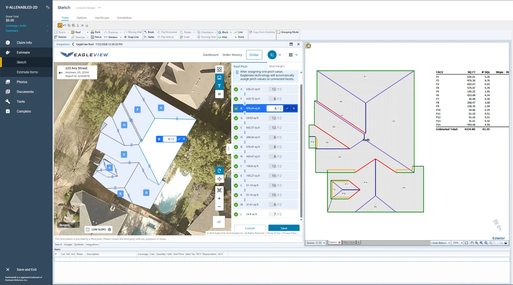
Eagleview’s 2D-to-3D pitch editor capabilities are now available directly within Xactimate®, giving roofers and adjusters a faster, more efficient way to create the 3D roof sketches they need while staying in the platform where they’re already working.

From a 2D Roof to a 3D Sketch

Eagleview introduced its pitch editor to solve a familiar challenge: what happens when a roof is available as a 2D diagram, but a 3D sketch is needed to complete an estimate?

With Eagleview’s 2D-to-3D capabilities, roofers and adjusters can add pitch information to a 2D roof diagram and turn it into a 3D roof sketch. Only one roof pitch needs to be entered; additional pitches can then be calculated automatically to build the 3D sketch.

Now, users can access that capability without leaving Xactimate.

Stay in Xactimate. Keep the Work Moving.

For roofers and adjusters, the benefit goes beyond creating a 3D model. It’s about eliminating friction.

Both professionals often manage multiple projects, estimates or claims simultaneously. Moving between applications, re-entering information or performing manual sketching adds steps—and those steps add up.

By bringing Eagleview’s pitch editor capabilities into Xactimate, roofers and adjusters can remain in the environment they already use to build estimates and complete their work. That means fewer interruptions and a more seamless path from roof information to estimate.

A faster roof-sketching workflow can help teams:

- Reduce manual work by converting 2D roof diagrams into usable 3D sketches.

- Stay in the flow by completing more of the process directly within Xactimate.

- Improve efficiency by reducing application switching and unnecessary workflow steps.

- Shorten cycle times by getting the roof information needed for an estimate faster.

- Increase capacity by enabling roofers and adjusters to complete more estimates and process more claims in less time.

These efficiencies can become especially valuable at scale. Saving steps on a single estimate or claim is helpful; saving them across hundreds or thousands can have a meaningful impact on productivity. During severe weather events, when demand and claim volumes can rise quickly, a more streamlined workflow can help roofing and insurance teams increase capacity and keep work moving.

More Than a 3D Sketch

Bringing pitch editing directly into Xactimate combines Eagleview’s property intelligence and 3D roof modeling capabilities with an estimating environment roofers and claims professionals use every day.

Instead of treating roof data, sketching and estimating as separate parts of the process, this experience brings them closer together—helping roofers and adjusters spend less time managing their workflow and more time completing estimates, serving customers and moving claims and projects forward.

Sketch Less. Get More Done.

Roofers and claims teams don’t need more steps. They need tools that remove them.

With Eagleview’s 2D-to-3D pitch editor capabilities now available within Xactimate, roofers and adjusters have another way to reduce manual work, maintain momentum and move from roof information to estimate more efficiently.

Stay in Xactimate. Build the 3D sketch. Keep the work moving.

Class (B2B/B2C)
B2B
Ingest Status
Rewritten
Dedupe hash
0c0eed981ccf05fffd2cd274ff72ee09
Press Eligible
Yes
Press Eligible Reason
Announces a workflow integration for roofing and insurance claims professionals.
Source Name
Eagleview
Original Summary

<p>For roofers and property claims professionals, speed matters. Every extra step in the estimating and claims process—from switching between platforms to manually sketching a roof—can [&#8230;]</p>
<p>The post <a href="https://www.eagleview.com/blog/from-2d-to-3d-now-without-leaving-xactim… 2D to 3D—Now Without Leaving Xactimate</a> appeared first on <a href="https://www.eagleview.com">Eagleview</a>.</p&gt;

Image URL
https://www.eagleview.com/wp-content/uploads/2026/08/123-Any-Street-Anytown-USA-12345-1200-x-800-px.png
Source Node
Content Hash (SHA-256, erste 32 hex)
efcaed1cee4f4ed0bc64198f5aafaa6b
Insurance Leaders Convene to Shape the Future of Claims and Underwriting in the Age of AI
Image File
Original HTML

Insurance Leaders Convene to Shape the Future of Claims and Underwriting in the Age of AI

ROCHESTER, N.Y., Oct. 9, 2026 — The U.S. averaged 23 weather and climate disasters per year over the past five years, each costing more than a billion dollars in claims, more than double the long-term average of about nine, according to NOAA. This is a crisis for the insurance industry and is forcing leaders to understand and scale new solutions to evolve with the times. Eagleview has long been a trusted partner in supporting the evolution of the industry and this convening with senior insurance leaders, innovators, and decisionmakers in Half Moon Bay focused on what the future of property intelligence, claims, risk, and AI-driven transformation mean.

Eagleview convenes insurance leaders to discuss claims and underwriting in the age of AI.

The conversation centered on the role of technology in improving core business processes as carriers navigate a rapidly changing risk landscape. Across the board, attendees expressed appetite for greater AI experimentation and a growing capacity to invest as the tools mature and begin to deliver on their potential. Hosted by Eagleview, a leader in aerial imagery and geospatial intelligence, the gathering known as the Property Claims Leadership Forum, also marked the launch of the company's newest research on how AI is transforming underwriting, claims, and decision-making across the insurance value chain.

"We believe coming together is the key to sustained growth in the industry and to navigating the evolution of the risk profile, particularly as AI makes it increasingly more possible to move from reactive to proactive management of risk," said Piers Dormeyer, CEO of Eagleview. "What came through this week is that leaders are deeply engaged in improving their businesses, and they increasingly see AI as the way to do it. Attendees are focused on both the near- and far-term changes AI is bringing, from the shifting dynamics of automation and loss adjustment expenses (LAE), to changes in how we process risk, to more tailored policy offerings, to new ways of improving speed to settlement and customer experience. More than ever, the industry is seeing clearly how these tools can deliver on that promise. The takeaway is that now is the time for carriers to invest and prepare for the challenges ahead."

Roughly two-thirds of insurers plan to increase AI investment over the next 12 to 24 months, and nearly 60% expect the technology to reshape their business models within three years, according to an April 2026 AM Best survey. Yet only about one in ten property-and-casualty carriers has moved AI beyond pilots and into production, per Capgemini's 2026 World Property and Casualty Insurance Report, even as the carriers furthest along report materially stronger revenue growth and share-price performance than their peers.

Closing the Information Gap Between Bind and Loss

Wildfire is the fastest-growing catastrophe risk of all, with insured losses climbing an estimated 12% a year, and in 2025, wildfires, storms, and floods drove a record 92% of the world's $107 billion in insured catastrophe losses. And the financial stakes keep climbing: global insured catastrophe losses have risen 5–7% a year in real terms over the long run, reaching $107 billion in 2025, according to Swiss Re.

Wildfire response is also what prompted Eagleview's newly unveiled white paper, From Pricing Risk to Managing It: Your 2026 Property Intelligence Briefing, on how AI and property intelligence are changing what carriers can do in the period between bind and loss. Authored by Patrick Gill, Eagleview's SVP and General Manager of Insurance and Commercial Solutions, and Jenna Kinsman, Eagleview's VP and Head of Insurance Solutions, the paper's central argument is that the information asymmetry between a carrier and the properties on its book is closing quickly enough that operating models built around that gap are beginning to show their age.

The research focuses on what carriers can act on now: portfolio intelligence and policy-in-force review, pre-loss identification and intervention, and faster, more accurate claims handling in the aftermath of catastrophic events. It grounds that argument in Eagleview's own experience during the Los Angeles wildfires earlier this year, when the company's claims-assessment teams worked manually through carrier property lists in the days after the fires. In parallel, Eagleview Horizon (the company's AI-powered geospatial property intelligence platform, now in early access) completed comparable portfolio-wide damage assessments in a fraction of the time of their human-only counterparts. The possibility to move that quickly held big promises.

"Eagleview Horizon took a process that would previously have taken weeks and completed it in minutes," said Gill. "That means faster delivery, a better experience for policyholders, and greater capacity to manage risk."

Technology Adoption Can't Come Fast Enough

Two questions ran through every session: how far and how fast the industry can move toward autonomous claims, and what AI ultimately means for the economics of coverage. Attendees noted that with catastrophe losses like the Los Angeles wildfires, its no longer a nice to have to be able to compress the coverage timelines but a competitive necessity. And yet, across sessions, leaders were clear that the goal is not to remove people from the process but to equip them so as to keep expert adjusters and underwriters in the loop while AI handles the scale and speed humans can't.

Carriers looking to move from pricing risk to managing it can read Eagleview's new white paper on AI and property intelligence, available now here.

Eagleview Horizon is currently available to select customers though our Eagleview Horizon Charter Program. Carriers interested in joining the program can contact Eagleview directly. Carriers interested in joining the Horizon early access program can contact Eagleview directly.

The Property Claims Leadership Forum will return for a second year with dates to be announced.

About Eagleview

Eagleview is an industry leader in geospatial intelligence (GeoAI), delivering AI-powered property intelligence solutions that enable customers across a broad range of industries to explore properties and structures with precision, act on solutions today, and identify tomorrow's opportunities. For more than 25 years, Eagleview has built proprietary property imaging and intelligence technology, accumulating in more than 300 patents meanwhile generating over 3.5 billion high-resolution images resulting a library that encompasses 96% of the U.S. population. With Eagleview's trusted insights, customers can make business decisions that matter.

Media contact

Kristina Libby

mediarelations@eagleview.com

Class (B2B/B2C)
B2B
Ingest Status
Rewritten
Dedupe hash
c3f99750237d512a272282f328c20254
Press Eligible
Yes
Press Eligible Reason
Manuelle Prüfung nötig. Risiko: MEDIUM. Flags: ['finance', 'numbers']. Stichprobe: False
Source Name
Eagleview
Original Summary

<p>At its inaugural Property Claims Leadership Forum, Eagleview brought together industry executives and unveiled new research exploring how artificial intelligence is transforming risk assessment, claims workflows, and decision-making across the insurance value chain.</p>
<p>The post <a href="https://www.eagleview.com/news-announcements/in-the-news/insurance-lead… Leaders Convene to Shape the Future of Claims and Underwriting in the Age of AI</a> appeared first on <a href="https://www.eagleview.com">Eagleview</a>.</p&gt;

Image URL
https://www.eagleview.com/wp-content/uploads/2025/06/EV-Opengraph-Thumbnail-Logo.png
Source Node
Content Hash (SHA-256, erste 32 hex)
d294f1c00dadc8aa22281592498fb159
25 Years Later, Eagleview’s Disaster Response Program Continues To Scale to Respond to Increasing Climate Disasters
Image File
Original HTML

25 Years Later, Eagleview’s Disaster Response Program Continues To Scale to Respond to Increasing Climate Disasters

Natural disasters in America are increasing 2-3x from previous standards, but program launched in the aftermath of September 11, 2001 provides valuable aerial imagery to help governments, insurance and broader industry respond effectively.

ROCHESTER, N.Y., Oct. 19, 2026 – In the past five years, the U.S. has experienced a yearly rise in major climate disasters. 2023 had 28. 2024 was 17. 2025 was 21. That is roughly 2-3x more than the long-term average, which is approximately nine, according to NOAA. These major climate disasters cost roughly a billion dollars. Many, including forest fires, far exceed that billion-dollar price tag. Even in years with fewer predicted weather events, organizations are still at elevated risk from any single event.

Eagleview's Disaster Response Program (DRP) provides rapid post-disaster aerial imagery and property data to customers.

Eagleview DRP orthogonal imagery captured in March and August 2026 shows after conditions in a Spokane-area neighborhood impacted by wildfire.

Eagleview DRP orthogonal imagery captured in March and August 2026 shows before conditions in a Spokane-area neighborhood impacted by wildfire.

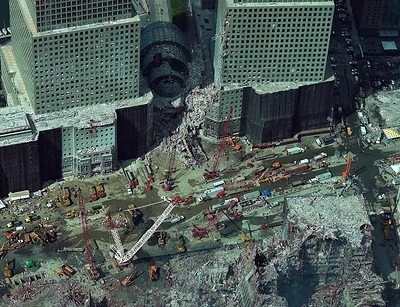
Image shows the site in NYC on 9/11 after Eagleview flew its first DRP flights to support the recovery efforts.

Often recovery is hampered by the capacity of responders, insurers, and other industry partners to understand the true severity of the damage. In those instances, aerial imagery determines the picture of risk for a professional, by showcasing how likely a roof is to fail, or how much storm damage a property has incurred, or the real condition of an asset. Without that information, wrong or unverifiable risk pictures cost insurers, contractors, government personnel and other industry leaders time and money. When the data isn't trusted enough to act on, the fallback is manual verification which eats valuable time and raises the costs of inspection.

Eagleview, one of the leading providers of aerial imagery, geospatial data, and property intelligence, provides those images in situations of crisis. And this year it's recognizing the 25th anniversary of its Disaster Response Program (DRP) which has grown from a single aerial mission flown in the aftermath of the September 11, 2001 attacks into an embedded, year-round operation supporting post-disaster recovery efforts nationwide.

"When we launched this effort 25 years ago, it was a singular response to a singular event," said Piers Dormeyer, CEO of Eagleview. "Today, we have a team behind this. Our customers don't experience disasters one at a time anymore, and neither can we. DRP exists so we can ensure people are safe, governments are supported, and the imagery that's needed to plan a recovery is there as quickly as possible."

From a Single Mission to a Standing Capability

In 2001, the company, then a small Rochester, New York-based startup, captured aerial imagery of the World Trade Center site in the weeks following the September 11 attacks and made that imagery available to responders on the ground. The mission, undertaken without a formal program in place, established the operating principle the company has built on ever since: that timely, geographically accurate imagery helps communities and institutions understand what has changed and make faster, better-informed recovery decisions.

That premise was tested at scale during Hurricane Katrina, when Eagleview's existing pre-event imagery of Orleans Parish, Louisiana enabled a direct comparison between pre- and post-storm conditions and supported the parish's recovery efforts for years afterward. It was during this period that the company further formalized the program and began offering it as a function customers could expect to rely on.

Over the past 25 years, DRP has supported government agencies, insurers, and infrastructure operators following hurricanes, wildfires, tornadoes, floods, and earthquakes across the United States, Canada, and Haiti. In the past two years alone, the program has responded to tornado activity in Illinois and Oklahoma; flooding in Hawaii and Kentucky; and wildfires in California, Washington, and elsewhere in North America. In several instances, the team managed more than one active response simultaneously including with Hurricanes Helene and Milton.

An Operating Model Built for Concurrent, Continuous Events

The company maintains a fleet of more than 100 aircraft, extensive baseline imagery coverage across the United States and Canada, and dedicated, geographically distributed aircraft and personnel positioned to reduce response time when multiple events occur in parallel.

"Our disaster response process is consistent with how we capture imagery under normal conditions; it's simply compressed into a substantially accelerated timeline," said Robert Locke, President of Eagleview's Government Solutions. "We monitor developing events, define the area of interest, build flight plans, and move aircraft into position, as soon as weather allows. The difference today is that this process now has dedicated personnel, staffed to respond to emergencies, not just when a single event demands it."

Since December 2025, Eagleview has responded to 17 severe weather events across 10 states.

"Our DRP effort is never easy, and it's never predictable but it is essential to the work we do here. In a way it's the heart and soul of our company," said Eagleview CEO Piers Dormeyer. "The impact it has on the people and communities we serve is significant, and that sets the standard that we continue to build toward."

About Eagleview

Eagleview is an industry leader in geospatial intelligence (GeoAI) delivering AI-powered property intelligence solutions that enable customers across a broad range of industries to accurately explore properties and structures, identify and implement solutions today, and find tomorrow's opportunities. For more than 25 years, Eagleview has built proprietary property imaging technology earning more than 300+ patents and generating over 3.5 billion high-resolution images resulting in a library that encompasses 96% of the U.S. population. With Eagleview's trusted insights, customers can make business decisions that matter.

Media contact

Kristina Libby

mediarelations@eagleview.com

Class (B2B/B2C)
B2B
Ingest Status
Rewritten
Dedupe hash
cebd883cc76b3081a0bf7fe96c2af51a
Press Eligible
Yes
Press Eligible Reason
Manuelle Prüfung nötig. Risiko: MEDIUM. Flags: ['numbers']. Stichprobe: False
Source Name
Eagleview
Original Summary

<p>Natural disasters in America are increasing 2-3x from previous standards, but program launched in the aftermath of September 11, 2001 provides valuable aerial imagery to help governments, insurance and broader industry respond effectively.</p>
<p>The post <a href="https://www.eagleview.com/news-announcements/in-the-news/25-years-later… Years Later, Eagleview&#8217;s Disaster Response Program Continues To Scale to Respond to Increasing Climate Disasters</a> appeared first on <a href="https://www.eagleview.com">Eagleview</a>.</p&gt;

Image URL
https://www.eagleview.com/wp-content/uploads/2026/10/Image-shows-the-site-in-NYC-on-9-11-after-Eagleview-flew-its-first-DRP-flights-to-support-the-recove.jpg
Source Node
Content Hash (SHA-256, erste 32 hex)
8d1c9256b6cc997af03984192b359f39
What Is the Digital Banking Portal?
Image File
Original HTML

In this video, we provide an introduction to our Digital Banking Portal.

This is an example of how you can offer your API products to different API consumer groups. Open banking is just one example.

This portal was created to give you a first-hand experience with APIs as they can be published to support an open banking initiative.

Watch this video to learn more about getting started with the Digital Banking Portal.

Class (B2B/B2C)
Ignore
Ingest Status
Rejected
Dedupe hash
cad36154e180578843148f392d63ec3a
Press Eligible
No
Press Eligible Reason
Text too short (73 words. Min: 150)
Source Name
Perforce Software
Original Summary

<span>What Is the Digital Banking Portal?</span>
<span><span>lreilly</span></span>
<span><time datetime="2025-07-10T15:19:35-05:00" title="Thursday, July 10, 2025 - 15:19">Thu, 07/10/2025 - 15:19</time>
</span>

<div class="field field--name-field-video field--type-entity-reference field--label-hidden"><div>

<div class="field field--name-field-wistia-video field--type-video-embed-field field--label-hidden field__item">

</div>

</div>
</div>

<div class="text-long"><div><div class="photoswipe-gallery"><p>In this video, we provide an introduction to our <a href="https://akana-digitalbanking.apiportal-eu.akana.com/#!welcome">Digital Banking Portal</a>.</p><p>This is an example of how you can offer your API products to different API consumer groups. Open banking is just one example.</p><p>This portal was created to give you a first-hand experience with APIs as they

Image URL
https://www.perforce.com/sites/default/files/image-social-share-default.jpg
Source Node
Content Hash (SHA-256, erste 32 hex)
2e1f7d929fd7417b6f7d321e9b6d68dd
OpenLogic
Original HTML

Control code, content, IP, and collaboration at any scale from idea to production.

Test and validate digital experiences and code quality across applications on any device.

Automate data delivery and data protection for DevOps and AI pipelines.

Scale operations with platform automation across on-prem and cloud topologies.

Not sure what you need? Let us help!

98% are confident in their ability to protect sensitive data in AI/ML. But 84% allow compliance exception. Find out why...

Not sure what you need? Let us help!

Class (B2B/B2C)
Ignore
Ingest Status
Rejected
Dedupe hash
db56ac1224db9f6bf2124db4e2c4220c
Press Eligible
No
Press Eligible Reason
Text too short (85 words. Min: 150)
Source Name
Perforce Software
Original Summary

<span>OpenLogic</span>

<div class="field field--name-field-product field--type-entity-reference field--label-hidden integration-product">
<div class="overflow-hidden text-ellipsis whitespace-nowrap">
<span class="topics-chip"><a href="https://www.perforce.com/taxonomy/term/866&quot; hreflang="en">OpenLogic</a></span> </div>

</div>
<span><span>ttrench</span></span>
<span><time datetime="2025-07-14T11:22:15-05:00" title="Monday, July 14, 2025 - 11:22">Mon, 07/14/2025 - 11:22</time>
</span>

<div class="field field--name-field-documentation field--type-link field--label-above">
<div>Documentation</div>
<a href="https://help.openlogic.com/">View Documentation</a>
</div>

<div class="field field--name-field-exclude-downloads-listt field--type-boolean field--label-above">
<div>Exclude From Downloads List</div>
On
</div>

Source Node
Content Hash (SHA-256, erste 32 hex)
057219eda26450ac7e656b39cbfb20f7